


franchevelle croix blanche route de lantenot croix du lieutenant

PatriceCocuaud
User
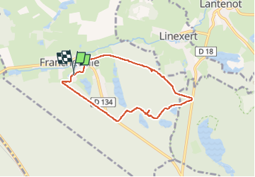

Length
6.4 km

Max alt
353 m

Uphill gradient
88 m
Km-Effort
7.6 km

Min alt
296 m

Downhill gradient
87 m
Boucle
Yes
Creation date :
2024-05-05 16:15:16.399
Updated on :
2024-05-05 17:49:46.914
1h34
Difficulty : Very easy

FREE GPS app for hiking
 SityTrail
IGN / Geographical institutes
SityTrail Plus
The world is yours!
About
Trail Walking of 6.4 km to be discovered at Bourgogne-Franche-Comté, Haute-Saône, Franchevelle. This trail is proposed by PatriceCocuaud.
Positioning
Country:
France
Region :
Bourgogne-Franche-Comté
Department/Province :
Haute-Saône
Municipality :
Franchevelle
Location:
Unknown
Start:(Dec)
Start:(UTM)
309527 ; 5290288 (32T) N.
Comments