


Saint Eulalie

Djac
User
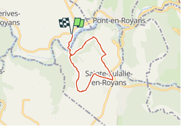

Length
6 km

Max alt
298 m

Uphill gradient
146 m
Km-Effort
7.9 km

Min alt
192 m

Downhill gradient
146 m
Boucle
Yes
Creation date :
2024-05-06 06:33:47.645
Updated on :
2024-05-06 06:34:15.548
1h48
Difficulty : Medium

FREE GPS app for hiking
 SityTrail
IGN / Geographical institutes
SityTrail Plus
The world is yours!
About
Trail Walking of 6 km to be discovered at Auvergne-Rhône-Alpes, Isère, Auberives-en-Royans. This trail is proposed by Djac.
Positioning
Country:
France
Region :
Auvergne-Rhône-Alpes
Department/Province :
Isère
Municipality :
Auberives-en-Royans
Location:
Unknown
Start:(Dec)
Start:(UTM)
683166 ; 4992121 (31T) N.
Comments