


PR_35_Bains-Oust_Aa-01_Circuit_Entre-Marais-Et-Chapelles

patrickdanilo
User
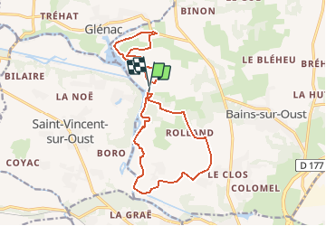

Length
16.3 km

Max alt
74 m

Uphill gradient
183 m
Km-Effort
18.8 km

Min alt
-1 m

Downhill gradient
188 m
Boucle
Yes
Creation date :
2019-02-09 16:16:07.644
Updated on :
2021-05-13 10:24:53.755
4h06
Difficulty : Easy

FREE GPS app for hiking
 SityTrail
IGN / Geographical institutes
SityTrail Plus
The world is yours!
About
Trail Walking of 16.3 km to be discovered at Brittany, Ille-et-Vilaine, Bains-sur-Oust. This trail is proposed by patrickdanilo.
Description
Randonnée Marche de 16 km à découvrir à BAINS-SUR-OUST, ILLE-ET-VILAINE, BRETAGNE. Cette randonnée est proposée par patrickdanilo
Photos

Positioning
Country:
France
Region :
Brittany
Department/Province :
Ille-et-Vilaine
Municipality :
Bains-sur-Oust
Location:
Unknown
Start:(Dec)
Start:(UTM)
566268 ; 5284447 (30T) N.
Comments