


Boucle le plantain 11k ink

ophness
User
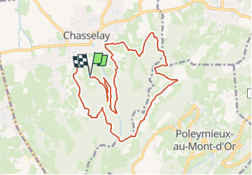

Length
10.9 km

Max alt
495 m

Uphill gradient
422 m
Km-Effort
16.5 km

Min alt
255 m

Downhill gradient
415 m
Boucle
Yes
Creation date :
2024-05-06 18:24:36.0
Updated on :
2024-05-06 18:24:37.219

FREE GPS app for hiking
 SityTrail
IGN / Geographical institutes
SityTrail Plus
The world is yours!
About
Trail of 10.9 km to be discovered at Auvergne-Rhône-Alpes, Rhône, Chasselay. This trail is proposed by ophness.
Positioning
Country:
France
Region :
Auvergne-Rhône-Alpes
Department/Province :
Rhône
Municipality :
Chasselay
Location:
Unknown
Start:(Dec)
Start:(UTM)
637547 ; 5080838 (31T) N.
Comments