
Nadaillat_Vigeral_3

jagarnier
User GUIDE
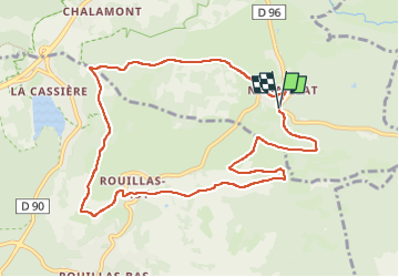

Length
10.4 km

Max alt
1037 m

Uphill gradient
268 m
Km-Effort
13.9 km

Min alt
866 m

Downhill gradient
271 m
Boucle
Yes
Creation date :
2024-05-07 06:58:18.027
Updated on :
2024-10-19 16:40:43.548
3h00
Difficulty : Medium

FREE GPS app for hiking
 SityTrail
IGN / Geographical institutes
SityTrail Plus
The world is yours!
About
Trail Walking of 10.4 km to be discovered at Auvergne-Rhône-Alpes, Puy-de-Dôme, Saint-Genès-Champanelle. This trail is proposed by jagarnier.
Photos

Positioning
Country:
France
Region :
Auvergne-Rhône-Alpes
Department/Province :
Puy-de-Dôme
Municipality :
Saint-Genès-Champanelle
Location:
Unknown
Start:(Dec)
Start:(UTM)
502591 ; 5059442 (31T) N.
Comments