


mas de Londres la jasse

Alain34jacou
User
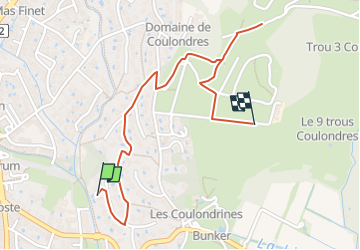

Length
2 km

Max alt
182 m

Uphill gradient
70 m
Km-Effort
2.7 km

Min alt
117 m

Downhill gradient
7 m
Boucle
No
Creation date :
2024-05-07 07:49:50.115
Updated on :
2024-05-07 07:49:52.232
37m
Difficulty : Easy

FREE GPS app for hiking
 SityTrail
IGN / Geographical institutes
SityTrail Plus
The world is yours!
About
Trail Walking of 2 km to be discovered at Occitania, Hérault, Saint-Gély-du-Fesc. This trail is proposed by Alain34jacou.
Description
rando pédestre facile
Positioning
Country:
France
Region :
Occitania
Department/Province :
Hérault
Municipality :
Saint-Gély-du-Fesc
Location:
Unknown
Start:(Dec)
Start:(UTM)
565371 ; 4838058 (31T) N.
Comments