


Gournier

daniellebou
User
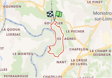

Length
4.5 km

Max alt
623 m

Uphill gradient
171 m
Km-Effort
6.8 km

Min alt
453 m

Downhill gradient
167 m
Boucle
Yes
Creation date :
2024-05-07 10:43:39.9
Updated on :
2024-05-25 19:02:34.305
1h32
Difficulty : Medium

FREE GPS app for hiking
 SityTrail
IGN / Geographical institutes
SityTrail Plus
The world is yours!
About
Trail Walking of 4.5 km to be discovered at Auvergne-Rhône-Alpes, Haute-Loire, Monistrol-sur-Loire. This trail is proposed by daniellebou.
Positioning
Country:
France
Region :
Auvergne-Rhône-Alpes
Department/Province :
Haute-Loire
Municipality :
Monistrol-sur-Loire
Location:
Unknown
Start:(Dec)
Start:(UTM)
589833 ; 5015870 (31T) N.
Comments