


château de crau

fitz2014
User
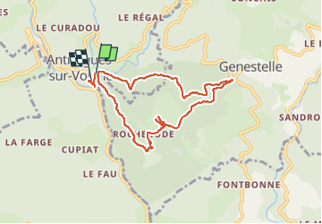

Length
8.2 km

Max alt
672 m

Uphill gradient
323 m
Km-Effort
12.4 km

Min alt
396 m

Downhill gradient
294 m
Boucle
Yes
Creation date :
2024-05-08 13:23:40.518
Updated on :
2024-05-08 16:22:35.354
2h58
Difficulty : Difficult

FREE GPS app for hiking
 SityTrail
IGN / Geographical institutes
SityTrail Plus
The world is yours!
About
Trail Walking of 8.2 km to be discovered at Auvergne-Rhône-Alpes, Ardèche, Vallées-d'Antraigues-Asperjoc. This trail is proposed by fitz2014.
Photos


Positioning
Country:
France
Region :
Auvergne-Rhône-Alpes
Department/Province :
Ardèche
Municipality :
Vallées-d'Antraigues-Asperjoc
Location:
Unknown
Start:(Dec)
Start:(UTM)
607747 ; 4952526 (31T) N.
Comments