


Gard Hérault etap1

taguette
User
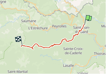

Length
20 km

Max alt
1050 m

Uphill gradient
1147 m
Km-Effort
33 km

Min alt
184 m

Downhill gradient
459 m
Boucle
No
Creation date :
2024-05-08 07:35:08.401
Updated on :
2024-05-08 16:41:22.368
9h04
Difficulty : Very difficult

FREE GPS app for hiking
 SityTrail
IGN / Geographical institutes
SityTrail Plus
The world is yours!
About
Trail Walking of 20 km to be discovered at Occitania, Gard, Saint-Jean-du-Gard. This trail is proposed by taguette.
Positioning
Country:
France
Region :
Occitania
Department/Province :
Gard
Municipality :
Saint-Jean-du-Gard
Location:
Unknown
Start:(Dec)
Start:(UTM)
571390 ; 4884876 (31T) N.
Comments