


andon/castelaras

yolaine saulnier
User
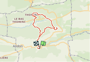

Length
16.5 km

Max alt
1393 m

Uphill gradient
708 m
Km-Effort
26 km

Min alt
1073 m

Downhill gradient
708 m
Boucle
Yes
Creation date :
2024-05-08 07:21:08.583
Updated on :
2024-05-08 19:21:16.893
4h34
Difficulty : Difficult

FREE GPS app for hiking
 SityTrail
IGN / Geographical institutes
SityTrail Plus
The world is yours!
About
Trail Walking of 16.5 km to be discovered at Provence-Alpes-Côte d'Azur, Maritime Alps, Andon. This trail is proposed by yolaine saulnier.
Photos


Positioning
Country:
France
Region :
Provence-Alpes-Côte d'Azur
Department/Province :
Maritime Alps
Municipality :
Andon
Location:
Unknown
Start:(Dec)
Start:(UTM)
324235 ; 4848699 (32T) N.
Comments