Trail Walking Coursegoules - Cime du Cheiron  - Photo
 bozo1970
bozo1970

User

© OpenStreetMap contributors
Length
Length
18 km
Max alt
Max alt
1754 m
Uphill gradient
Uphill gradient
969 m
Km-Effort
Km-Effort  
31 km
Min alt
Min alt
1055 m
Downhill gradient
Downhill gradient
972 m
Boucle
Boucle
Yes
Creation date :
2024-05-09 07:08:44.0
Updated on :
2024-05-10 08:21:52.954

(0 Reviews)

Walking
Walking
5h54
Difficulty : Very difficult

Scan this QR Code to open this trail in the SityTrail application

FREE GPS app for hiking

Logo SityTrail SityTrail

IGN / Geographical institutes

Download SityTrail from the App Store Download SityTrail from Google Play

Logo SityTrail SityTrail Plus

The world is yours!

Download SityTrail from the App Store Download SityTrail from Google Play Download SityTrail on Huawei AppGallery

About

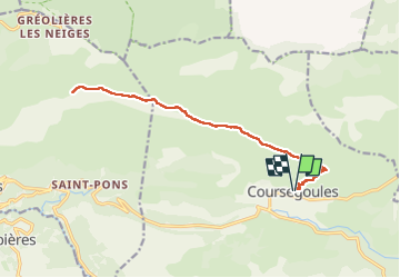
Trail Walking of 18 km to be discovered at Provence-Alpes-Côte d'Azur, Maritime Alps, Coursegoules. This trail is proposed by bozo1970.

Description

Départ de Coursegoules
Montée à la Baisse de Viériou en 43' D  306 et 2km
Téléski des Crêtes en 3h10' D  866 et 8km400
A/R en 5h54' D  1106 et 18km
Jolie vue à la Baisse de Vieriou côté Mer et Mercantour
Aucun intérêt pour cette Crête
L'arrivée sur les remontées mécaniques gâche tout
Pas pû faire le sommet car le ciel était menaçant
Trop long depuis Coursegoules
Couple d'aigle   bébé

Elevation profile

Positioning

Country:
France
Region :
Provence-Alpes-Côte d'Azur
Department/Province :
Maritime Alps
Municipality :
Coursegoules
Location:
Unknown
Start:(UTM)
342685 ; 4850863 (32T) N.


Close
My subscriptions