


Étang de Comte

lebarça
User
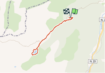

Length
7.3 km

Max alt
1755 m

Uphill gradient
318 m
Km-Effort
11.5 km

Min alt
1447 m

Downhill gradient
306 m
Boucle
Yes
Creation date :
2024-05-09 08:36:03.0
Updated on :
2024-05-09 13:44:48.28

FREE GPS app for hiking
 SityTrail
IGN / Geographical institutes
SityTrail Plus
The world is yours!
About
Trail of 7.3 km to be discovered at Occitania, Ariège, Mérens-les-Vals. This trail is proposed by lebarça.
Positioning
Country:
France
Region :
Occitania
Department/Province :
Ariège
Municipality :
Mérens-les-Vals
Location:
Unknown
Start:(Dec)
Start:(UTM)
402697 ; 4722398 (31T) N.
Comments