


Moye 1h30

Pierrannick
User
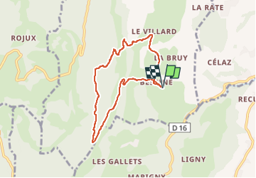

Length
7 km

Max alt
898 m

Uphill gradient
348 m
Km-Effort
11.7 km

Min alt
551 m

Downhill gradient
348 m
Boucle
Yes
Creation date :
2024-05-09 15:33:05.0
Updated on :
2024-05-09 17:08:56.03
1h28
Difficulty : Unknown

FREE GPS app for hiking
 SityTrail
IGN / Geographical institutes
SityTrail Plus
The world is yours!
About
Trail Walking of 7 km to be discovered at Auvergne-Rhône-Alpes, Upper Savoy, Moye. This trail is proposed by Pierrannick.
Positioning
Country:
France
Region :
Auvergne-Rhône-Alpes
Department/Province :
Upper Savoy
Municipality :
Moye
Location:
Unknown
Start:(Dec)
Start:(UTM)
725370 ; 5080949 (31T) N.
Comments