


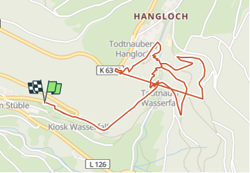
Rund Wanderweg Todtnau Blackforestline

patrickbeyrath
User

Length
3.5 km

Max alt
967 m

Uphill gradient
246 m
Km-Effort
6.8 km

Min alt
809 m

Downhill gradient
246 m
Boucle
Yes
Creation date :
2024-05-10 05:50:25.4
Updated on :
2024-05-22 08:05:09.983
1h33
Difficulty : Medium

FREE GPS app for hiking
 SityTrail
IGN / Geographical institutes
SityTrail Plus
The world is yours!
About
Trail Walking of 3.5 km to be discovered at Baden-Württemberg, Landkreis Lörrach, Todtnau. This trail is proposed by patrickbeyrath.
Positioning
Country:
Germany
Region :
Baden-Württemberg
Department/Province :
Landkreis Lörrach
Municipality :
Todtnau
Location:
Unknown
Start:(Dec)
Start:(UTM)
420090 ; 5299367 (32T) N.
Comments