


Les Sources de Lalliers

HUBY
User
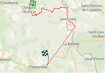

Length
27 km

Max alt
1309 m

Uphill gradient
1070 m
Km-Effort
42 km

Min alt
969 m

Downhill gradient
1059 m
Boucle
No
Creation date :
2024-05-09 07:07:15.601
Updated on :
2024-05-10 07:52:31.274
5h16
Difficulty : Very difficult

FREE GPS app for hiking
 SityTrail
IGN / Geographical institutes
SityTrail Plus
The world is yours!
About
Trail Walking of 27 km to be discovered at Occitania, Lozère, Cheylard-l'Évêque. This trail is proposed by HUBY.
Description
Perchant Conception
Photos

Positioning
Country:
France
Region :
Occitania
Department/Province :
Lozère
Municipality :
Cheylard-l'Évêque
Location:
Unknown
Start:(Dec)
Start:(UTM)
563699 ; 4944168 (31T) N.
Comments