


Breulliet Saint Sulpice de Favieres

olivieraron
User
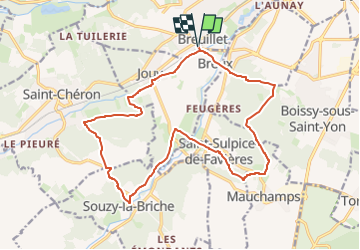

Length
17.8 km

Max alt
160 m

Uphill gradient
338 m
Km-Effort
22 km

Min alt
56 m

Downhill gradient
338 m
Boucle
Yes
Creation date :
2024-05-10 10:11:54.346
Updated on :
2024-05-10 10:15:51.287
5h03
Difficulty : Very difficult

FREE GPS app for hiking
 SityTrail
IGN / Geographical institutes
SityTrail Plus
The world is yours!
About
Trail Walking of 17.8 km to be discovered at Ile-de-France, Essonne, Breuillet. This trail is proposed by olivieraron.
Positioning
Country:
France
Region :
Ile-de-France
Department/Province :
Essonne
Municipality :
Breuillet
Location:
Unknown
Start:(Dec)
Start:(UTM)
438880 ; 5379432 (31U) N.
Comments