


saint nom

olivieraron
User
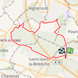

Length
16.5 km

Max alt
192 m

Uphill gradient
347 m
Km-Effort
21 km

Min alt
93 m

Downhill gradient
342 m
Boucle
Yes
Creation date :
2019-01-14 09:45:56.489
Updated on :
2019-01-14 09:45:56.538
1h40
Difficulty : Unknown

FREE GPS app for hiking
 SityTrail
IGN / Geographical institutes
SityTrail Plus
The world is yours!
About
Trail Other activity of 16.5 km to be discovered at Ile-de-France, Yvelines, L'Étang-la-Ville. This trail is proposed by olivieraron.
Positioning
Country:
France
Region :
Ile-de-France
Department/Province :
Yvelines
Municipality :
L'Étang-la-Ville
Location:
Unknown
Start:(Dec)
Start:(UTM)
430400 ; 5413138 (31U) N.
Comments