


col des Soubeyrand

phila128
User

Length
12.4 km

Max alt
1160 m

Uphill gradient
561 m
Km-Effort
19.9 km

Min alt
659 m

Downhill gradient
569 m
Boucle
Yes
Creation date :
2024-05-10 07:47:22.858
Updated on :
2024-05-10 12:52:54.518
3h40
Difficulty : Medium

FREE GPS app for hiking
 SityTrail
IGN / Geographical institutes
SityTrail Plus
The world is yours!
About
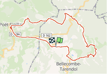
Trail Walking of 12.4 km to be discovered at Auvergne-Rhône-Alpes, Drôme, Bellecombe-Tarendol. This trail is proposed by phila128.
Positioning
Country:
France
Region :
Auvergne-Rhône-Alpes
Department/Province :
Drôme
Municipality :
Bellecombe-Tarendol
Location:
Unknown
Start:(Dec)
Start:(UTM)
686847 ; 4914518 (31T) N.
Comments