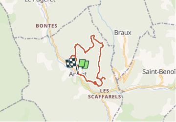
Grès d'Annot et Bau de Parrou (Annot 04)

Clo0413
User

Length
13.8 km

Max alt
1189 m

Uphill gradient
883 m
Km-Effort
26 km

Min alt
689 m

Downhill gradient
880 m
Boucle
Yes
Creation date :
2024-05-11 06:33:15.573
Updated on :
2024-05-13 12:38:30.331
4h53
Difficulty : Medium

FREE GPS app for hiking
 SityTrail
IGN / Geographical institutes
SityTrail Plus
The world is yours!
About
Trail Walking of 13.8 km to be discovered at Provence-Alpes-Côte d'Azur, Alpes-de-Haute-Provence, Annot. This trail is proposed by Clo0413.
Positioning
Country:
France
Region :
Provence-Alpes-Côte d'Azur
Department/Province :
Alpes-de-Haute-Provence
Municipality :
Annot
Location:
Unknown
Start:(Dec)
Start:(UTM)
312829 ; 4870678 (32T) N.
Comments