


2024-05-16-etang-rompu

Rando MLC
User
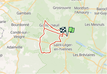

Length
30 km

Max alt
192 m

Uphill gradient
409 m
Km-Effort
36 km

Min alt
118 m

Downhill gradient
409 m
Boucle
Yes
Creation date :
2024-05-12 08:22:16.364
Updated on :
2024-05-12 10:28:36.34
8h07
Difficulty : Very difficult

FREE GPS app for hiking
 SityTrail
IGN / Geographical institutes
SityTrail Plus
The world is yours!
About
Trail Walking of 30 km to be discovered at Ile-de-France, Yvelines, Saint-Léger-en-Yvelines. This trail is proposed by Rando MLC.
Positioning
Country:
France
Region :
Ile-de-France
Department/Province :
Yvelines
Municipality :
Saint-Léger-en-Yvelines
Location:
Unknown
Start:(Dec)
Start:(UTM)
409843 ; 5399087 (31U) N.
Comments