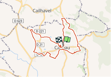
Boucle au Sud de Montréal dans l'Aude

Combaut11
User

Length
9.5 km

Max alt
289 m

Uphill gradient
159 m
Km-Effort
11.6 km

Min alt
208 m

Downhill gradient
161 m
Boucle
Yes
Creation date :
2024-05-12 10:29:51.735
Updated on :
2024-05-12 12:07:23.708
2h38
Difficulty : Medium

FREE GPS app for hiking
 SityTrail
IGN / Geographical institutes
SityTrail Plus
The world is yours!
About
Trail Walking of 9.5 km to be discovered at Occitania, Aude, Cailhau. This trail is proposed by Combaut11.
Description
Balade entre vignes, oliveraies, genêts, forêts, et guarriges
Positioning
Country:
France
Region :
Occitania
Department/Province :
Aude
Municipality :
Cailhau
Location:
Unknown
Start:(Dec)
Start:(UTM)
429910 ; 4777504 (31T) N.
Comments