


20240512 MN 3 ponts

Jeanclaudebic
User
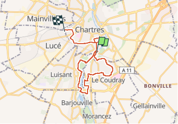

Length
12.8 km

Max alt
158 m

Uphill gradient
124 m
Km-Effort
14.4 km

Min alt
125 m

Downhill gradient
100 m
Boucle
No
Creation date :
2024-05-12 07:16:50.566
Updated on :
2024-05-12 12:05:25.616
4h48
Difficulty : Very easy

FREE GPS app for hiking
 SityTrail
IGN / Geographical institutes
SityTrail Plus
The world is yours!
About
Trail Nordic walking of 12.8 km to be discovered at Centre-Loire Valley, Eure-et-Loir, Chartres. This trail is proposed by Jeanclaudebic.
Positioning
Country:
France
Region :
Centre-Loire Valley
Department/Province :
Eure-et-Loir
Municipality :
Chartres
Location:
Unknown
Start:(Dec)
Start:(UTM)
388546 ; 5365546 (31U) N.
Comments