


boucle de 3 jours - départ Saint Martin en Vercors

vsna
User
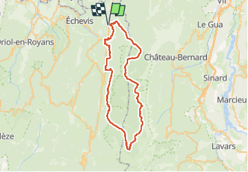

Length
63 km

Max alt
1703 m

Uphill gradient
2309 m
Km-Effort
93 km

Min alt
696 m

Downhill gradient
2306 m
Boucle
Yes
Creation date :
2024-05-10 06:21:57.517
Updated on :
2024-05-13 08:25:36.771
16h00
Difficulty : Medium

FREE GPS app for hiking
 SityTrail
IGN / Geographical institutes
SityTrail Plus
The world is yours!
About
Trail Walking of 63 km to be discovered at Auvergne-Rhône-Alpes, Drôme, Saint-Martin-en-Vercors. This trail is proposed by vsna.
Positioning
Country:
France
Region :
Auvergne-Rhône-Alpes
Department/Province :
Drôme
Municipality :
Saint-Martin-en-Vercors
Location:
Unknown
Start:(Dec)
Start:(UTM)
692445 ; 4988130 (31T) N.
Comments