Trail Walking Roquebrune-sur-Argens - Tour du lac de l'arèna - Photo
 Roger59
Roger59

User

© OpenStreetMap contributors
Length
Length
3.7 km
Max alt
Max alt
14 m
Uphill gradient
Uphill gradient
17 m
Km-Effort
Km-Effort  
4 km
Min alt
Min alt
7 m
Downhill gradient
Downhill gradient
16 m
Boucle
Boucle
Yes
Creation date :
2024-05-13 07:41:24.023
Updated on :
2024-05-13 12:43:05.518

(0 Reviews)

Walking
Walking
56m
Difficulty : Easy

Scan this QR Code to open this trail in the SityTrail application

FREE GPS app for hiking

Logo SityTrail SityTrail

IGN / Geographical institutes

Download SityTrail from the App Store Download SityTrail from Google Play

Logo SityTrail SityTrail World

The world is yours!

Download SityTrail from the App Store Download SityTrail from Google Play Download SityTrail on Huawei AppGallery

About

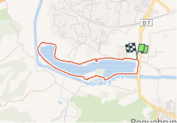
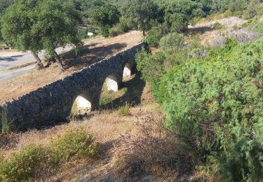
Trail Walking of 3.7 km to be discovered at Provence-Alpes-Côte d'Azur, Var, Roquebrune-sur-Argens. This trail is proposed by Roger59.

Description

Petite randonnée facile pas de difficultés et en partie ombragé ,plusieurs parking à disposition .

Elevation profile

Photos

Positioning

Country:
France
Region :
Provence-Alpes-Côte d'Azur
Department/Province :
Var
Municipality :
Roquebrune-sur-Argens
Location:
Unknown
Start:(UTM)
308461 ; 4813734 (32T) N.

Trails nearby

Trail Walking Roquebrune-sur-Argens - SityTrail - Les 25 ponts-Roquebrune sur Argens-28-01-22 - Photo
Walking
GUIDE
affinetataille

Walking

Medium
(1)
Roquebrune-sur-Argens, Provence-Alpes-Côte d'Azur, Var, France
14.4 km | 20 km-effort
6h 0min
Yes
Trail Walking Roquebrune-sur-Argens - Rocher de Roquebrune, les Trois Croix - Photo
Walking
tracegps

Walking

Difficult
(4)
Roquebrune-sur-Argens, Provence-Alpes-Côte d'Azur, Var, France
7 km | 11.4 km-effort
4h 15min
Yes
Trail On foot Puget-sur-Argens - PUGET SUR ARGENS- gazoduc-Terres Gastes DRI - Photo
On foot
ripoll dominique

On foot

Easy
(1)
Puget-sur-Argens, Provence-Alpes-Côte d'Azur, Var, France
7.7 km | 8.9 km-effort
2h 1min
Yes
Trail Walking Roquebrune-sur-Argens - 2023-10-25_17h14m36_Randonn_e-27 - Photo
Walking

Walking

Difficult
(1)
Roquebrune-sur-Argens, Provence-Alpes-Côte d'Azur, Var, France
9.2 km | 12.6 km-effort
2h 52min
Yes
Trail On foot Roquebrune-sur-Argens - Roquebrune sur argens-Les 25 Ponds-ND de la pitié- Lac des clos - Photo
On foot
ripoll dominique

On foot

Easy
(1)
Roquebrune-sur-Argens, Provence-Alpes-Côte d'Azur, Var, France
11.9 km | 17 km-effort
3h 51min
Yes
Trail Walking Roquebrune-sur-Argens - les hauts de Roquebrune sur Argens - Photo
Walking
GUIDE
nadinebondoux

Walking

Easy
Roquebrune-sur-Argens, Provence-Alpes-Côte d'Azur, Var, France
6.2 km | 8.9 km-effort
2h 9min
Yes
Trail Walking Roquebrune-sur-Argens - Le sentier découverte des 25 ponts - Photo
Walking
marmotte83

Walking

Very easy
(1)
Roquebrune-sur-Argens, Provence-Alpes-Côte d'Azur, Var, France
4.5 km | 6 km-effort
Unknown
Yes
Trail Mountain bike Roquebrune-sur-Argens - 2013 05 01 - Photo
Mountain bike
lboubis

Mountain bike

Medium
(1)
Roquebrune-sur-Argens, Provence-Alpes-Côte d'Azur, Var, France
23 km | 33 km-effort
4h 8min
No
Trail Walking Roquebrune-sur-Argens - Circuit de l'eau - Photo
Walking
Pascal-83

Walking

Easy
Roquebrune-sur-Argens, Provence-Alpes-Côte d'Azur, Var, France
4.3 km | 5.9 km-effort
1h 19min
Yes


Close
My subscriptions