


suuntoapp-Hiking-2024-05-10T08-54-36Z

holtzv
User GUIDE
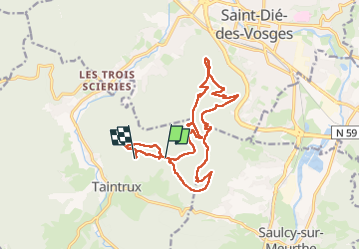

Length
18.8 km

Max alt
762 m

Uphill gradient
1006 m
Km-Effort
32 km

Min alt
463 m

Downhill gradient
880 m
Boucle
No
Creation date :
2024-05-13 13:08:55.117
Updated on :
2024-05-13 13:16:48.294
7h14
Difficulty : Medium

FREE GPS app for hiking
 SityTrail
IGN / Geographical institutes
SityTrail Plus
The world is yours!
About
Trail Walking of 18.8 km to be discovered at Grand Est, Vosges, Taintrux. This trail is proposed by holtzv.
Photos


Positioning
Country:
France
Region :
Grand Est
Department/Province :
Vosges
Municipality :
Taintrux
Location:
Unknown
Start:(Dec)
Start:(UTM)
345410 ; 5346911 (32U) N.
Comments