


c1

Mariolebeno
User
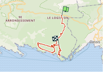

Length
16.7 km

Max alt
370 m

Uphill gradient
855 m
Km-Effort
29 km

Min alt
6 m

Downhill gradient
1005 m
Boucle
No
Creation date :
2024-05-13 08:49:14.12
Updated on :
2024-05-13 15:13:00.185
3h31
Difficulty : Very difficult

FREE GPS app for hiking
 SityTrail
IGN / Geographical institutes
SityTrail Plus
The world is yours!
About
Trail Walking of 16.7 km to be discovered at Provence-Alpes-Côte d'Azur, Bouches-du-Rhône, Marseille. This trail is proposed by Mariolebeno.
Positioning
Country:
France
Region :
Provence-Alpes-Côte d'Azur
Department/Province :
Bouches-du-Rhône
Municipality :
Marseille
Location:
9th Arrondissement
Start:(Dec)
Start:(UTM)
703011 ; 4790152 (31T) N.
Comments