


SityTrail - Apcher la Tuyère

raymondfn
User
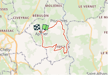

Length
11.6 km

Max alt
1113 m

Uphill gradient
279 m
Km-Effort
15.3 km

Min alt
886 m

Downhill gradient
280 m
Boucle
Yes
Creation date :
2024-05-13 19:49:25.22
Updated on :
2024-05-24 14:19:45.152
3h28
Difficulty : Difficult

FREE GPS app for hiking
 SityTrail
IGN / Geographical institutes
SityTrail Plus
The world is yours!
About
Trail Walking of 11.6 km to be discovered at Occitania, Lozère, Prunières. This trail is proposed by raymondfn.
Positioning
Country:
France
Region :
Occitania
Department/Province :
Lozère
Municipality :
Prunières
Location:
Unknown
Start:(Dec)
Start:(UTM)
525479 ; 4962532 (31T) N.
Comments
Balade agréable