


le testonnier

vincente204
User
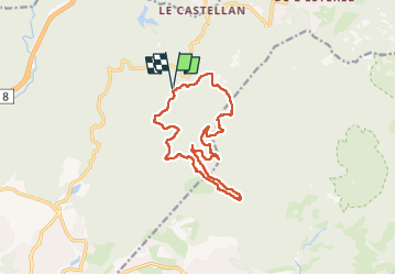

Length
14.2 km

Max alt
397 m

Uphill gradient
363 m
Km-Effort
19.1 km

Min alt
82 m

Downhill gradient
364 m
Boucle
Yes
Creation date :
2024-05-14 07:23:26.729
Updated on :
2024-05-14 13:01:08.816
3h55
Difficulty : Very difficult

FREE GPS app for hiking
 SityTrail
IGN / Geographical institutes
SityTrail Plus
The world is yours!
About
Trail Walking of 14.2 km to be discovered at Provence-Alpes-Côte d'Azur, Var, Fréjus. This trail is proposed by vincente204.
Description
facile
Positioning
Country:
France
Region :
Provence-Alpes-Côte d'Azur
Department/Province :
Var
Municipality :
Fréjus
Location:
Unknown
Start:(Dec)
Start:(UTM)
322258 ; 4818308 (32T) N.
Comments