


15/05/24

Alain28/01
User
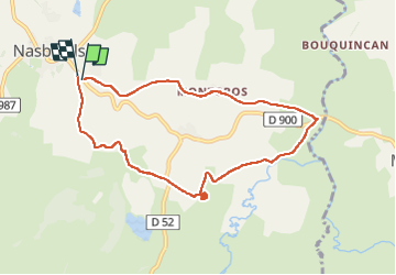

Length
8.7 km

Max alt
1224 m

Uphill gradient
150 m
Km-Effort
10.7 km

Min alt
1152 m

Downhill gradient
154 m
Boucle
Yes
Creation date :
2024-05-15 07:29:24.724
Updated on :
2024-05-15 10:11:46.841
2h03
Difficulty : Easy

FREE GPS app for hiking
 SityTrail
IGN / Geographical institutes
SityTrail Plus
The world is yours!
About
Trail Walking of 8.7 km to be discovered at Occitania, Lozère, Nasbinals. This trail is proposed by Alain28/01.
Description
cascade de Retord. Nasbinals
Positioning
Country:
France
Region :
Occitania
Department/Province :
Lozère
Municipality :
Nasbinals
Location:
Unknown
Start:(Dec)
Start:(UTM)
504117 ; 4945093 (31T) N.
Comments