


Kreizerbuch

collignpn
User GUIDE
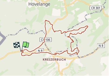

Length
10.5 km

Max alt
408 m

Uphill gradient
200 m
Km-Effort
13.2 km

Min alt
320 m

Downhill gradient
199 m
Boucle
Yes
Creation date :
2024-05-15 12:03:15.0
Updated on :
2024-05-15 14:56:34.734
0m
Difficulty : Very easy

FREE GPS app for hiking
 SityTrail
IGN / Geographical institutes
SityTrail Plus
The world is yours!
About
Trail Nordic walking of 10.5 km to be discovered at Unknown, Canton Capellen, Habscht. This trail is proposed by collignpn.
Photos


Positioning
Country:
Luxembourg
Region :
Unknown
Department/Province :
Canton Capellen
Municipality :
Habscht
Location:
Hobscheid
Start:(Dec)
Start:(UTM)
708841 ; 5509780 (31U) N.
Comments