


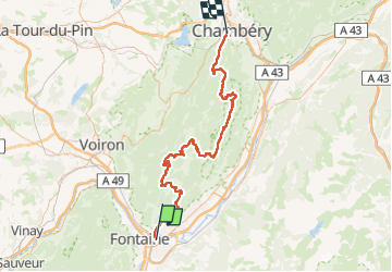
SityTrail - Traversée chartreuse

Clément Baldzuhn
User

Length
96 km

Max alt
1887 m

Uphill gradient
6360 m
Km-Effort
181 km

Min alt
214 m

Downhill gradient
6300 m
Boucle
No
Creation date :
2024-05-15 20:39:06.867
Updated on :
2024-05-15 20:40:11.083
0m
Difficulty : Difficult

FREE GPS app for hiking
 SityTrail
IGN / Geographical institutes
SityTrail Plus
The world is yours!
About
Trail Running of 96 km to be discovered at Auvergne-Rhône-Alpes, Isère, Grenoble. This trail is proposed by Clément Baldzuhn.
Positioning
Country:
France
Region :
Auvergne-Rhône-Alpes
Department/Province :
Isère
Municipality :
Grenoble
Location:
Unknown
Start:(Dec)
Start:(UTM)
714326 ; 5008225 (31T) N.
Comments