


16/05/24

Alain28/01
User
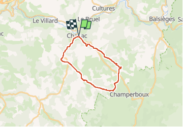

Length
22 km

Max alt
936 m

Uphill gradient
413 m
Km-Effort
27 km

Min alt
652 m

Downhill gradient
412 m
Boucle
Yes
Creation date :
2024-05-16 06:44:15.308
Updated on :
2024-05-16 13:32:29.857
4h51
Difficulty : Difficult

FREE GPS app for hiking
 SityTrail
IGN / Geographical institutes
SityTrail Plus
The world is yours!
About
Trail Walking of 22 km to be discovered at Occitania, Lozère, Chanac. This trail is proposed by Alain28/01.
Description
Randonnée au départ de Chanac, à travers le causse de Sauveterre.
Positioning
Country:
France
Region :
Occitania
Department/Province :
Lozère
Municipality :
Chanac
Location:
Chanac
Start:(Dec)
Start:(UTM)
527477 ; 4923613 (31T) N.
Comments