


rando Bucey 16 mai 2024

evelyne10
User
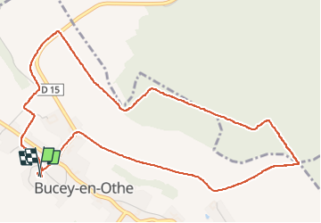

Length
5.9 km

Max alt
240 m

Uphill gradient
117 m
Km-Effort
7.4 km

Min alt
141 m

Downhill gradient
117 m
Boucle
Yes
Creation date :
2024-05-16 11:59:21.652
Updated on :
2024-05-16 13:43:35.065
1h43
Difficulty : Easy

FREE GPS app for hiking
 SityTrail
IGN / Geographical institutes
SityTrail Plus
The world is yours!
About
Trail Walking of 5.9 km to be discovered at Grand Est, Aube, Bucey-en-Othe. This trail is proposed by evelyne10.
Photos


Positioning
Country:
France
Region :
Grand Est
Department/Province :
Aube
Municipality :
Bucey-en-Othe
Location:
Unknown
Start:(Dec)
Start:(UTM)
563819 ; 5345552 (31U) N.
Comments