


beulotte saint laurent

jeanclaudeperrin
User
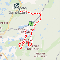

Length
6 km

Max alt
708 m

Uphill gradient
109 m
Km-Effort
7.6 km

Min alt
607 m

Downhill gradient
158 m
Boucle
No
Creation date :
2015-04-09 00:00:00.0
Updated on :
2015-04-09 00:00:00.0
1h38
Difficulty : Easy

FREE GPS app for hiking
 SityTrail
IGN / Geographical institutes
SityTrail Plus
The world is yours!
About
Trail Walking of 6 km to be discovered at Bourgogne-Franche-Comté, Haute-Saône, Servance-Miellin. This trail is proposed by jeanclaudeperrin.
Positioning
Country:
France
Region :
Bourgogne-Franche-Comté
Department/Province :
Haute-Saône
Municipality :
Servance-Miellin
Location:
Servance
Start:(Dec)
Start:(UTM)
326725 ; 5302374 (32T) N.
Comments