


l'enclose de Monthury

jeanclaudeperrin
User

Length
12.6 km

Max alt
708 m

Uphill gradient
267 m
Km-Effort
16.1 km

Min alt
540 m

Downhill gradient
264 m
Boucle
Yes
Creation date :
2015-04-09 00:00:00.0
Updated on :
2015-04-09 00:00:00.0
3h28
Difficulty : Easy

FREE GPS app for hiking
 SityTrail
IGN / Geographical institutes
SityTrail Plus
The world is yours!
About
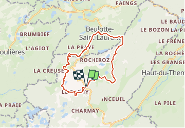
Trail Walking of 12.6 km to be discovered at Bourgogne-Franche-Comté, Haute-Saône, Servance-Miellin. This trail is proposed by jeanclaudeperrin.
Description
Mille Etangs par la droite de Beulotte
Positioning
Country:
France
Region :
Bourgogne-Franche-Comté
Department/Province :
Haute-Saône
Municipality :
Servance-Miellin
Location:
Servance
Start:(Dec)
Start:(UTM)
325554 ; 5300790 (32T) N.
Comments