


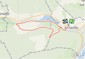
Arnaville 7,4 km HS

bstebe
User

Length
7.4 km

Max alt
278 m

Uphill gradient
134 m
Km-Effort
9.2 km

Min alt
173 m

Downhill gradient
134 m
Boucle
Yes
Creation date :
2024-05-16 15:33:39.034
Updated on :
2024-05-16 15:34:47.407
2h05
Difficulty : Medium

FREE GPS app for hiking
 SityTrail
IGN / Geographical institutes
SityTrail Plus
The world is yours!
About
Trail Walking of 7.4 km to be discovered at Grand Est, Meurthe-et-Moselle, Arnaville. This trail is proposed by bstebe.
Positioning
Country:
France
Region :
Grand Est
Department/Province :
Meurthe-et-Moselle
Municipality :
Arnaville
Location:
Unknown
Start:(Dec)
Start:(UTM)
282750 ; 5433013 (32U) N.
Comments