


Entrecasteaux St Antonin

bernir
User
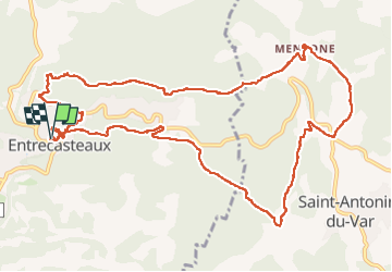

Length
14.9 km

Max alt
317 m

Uphill gradient
426 m
Km-Effort
21 km

Min alt
148 m

Downhill gradient
427 m
Boucle
Yes
Creation date :
2024-05-16 08:16:12.983
Updated on :
2024-05-17 07:13:52.959
7h30
Difficulty : Medium

FREE GPS app for hiking
 SityTrail
IGN / Geographical institutes
SityTrail Plus
The world is yours!
About
Trail Walking of 14.9 km to be discovered at Provence-Alpes-Côte d'Azur, Var, Entrecasteaux. This trail is proposed by bernir.
Positioning
Country:
France
Region :
Provence-Alpes-Côte d'Azur
Department/Province :
Var
Municipality :
Entrecasteaux
Location:
Unknown
Start:(Dec)
Start:(UTM)
277094 ; 4821703 (32T) N.
Comments