


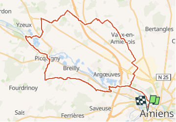
Balade autour de Picquigny et belloy

ORTAX
User

Length
45 km

Max alt
97 m

Uphill gradient
472 m
Km-Effort
52 km

Min alt
9 m

Downhill gradient
471 m
Boucle
Yes
Creation date :
2024-05-17 09:59:48.711
Updated on :
2024-05-17 10:01:29.489
3h34
Difficulty : Very difficult

FREE GPS app for hiking
 SityTrail
IGN / Geographical institutes
SityTrail Plus
The world is yours!
About
Trail Mountain bike of 45 km to be discovered at Hauts-de-France, Somme, Amiens. This trail is proposed by ORTAX.
Positioning
Country:
France
Region :
Hauts-de-France
Department/Province :
Somme
Municipality :
Amiens
Location:
Unknown
Start:(Dec)
Start:(UTM)
448521 ; 5527350 (31U) N.
Comments