


lamure reconnaissance OGR

gilles69400
User
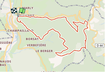

Length
12.4 km

Max alt
835 m

Uphill gradient
519 m
Km-Effort
19.3 km

Min alt
414 m

Downhill gradient
511 m
Boucle
Yes
Creation date :
2024-05-17 07:08:26.948
Updated on :
2024-05-17 15:39:24.173
4h23
Difficulty : Very difficult

FREE GPS app for hiking
 SityTrail
IGN / Geographical institutes
SityTrail Plus
The world is yours!
About
Trail Walking of 12.4 km to be discovered at Auvergne-Rhône-Alpes, Rhône, Lamure-sur-Azergues. This trail is proposed by gilles69400.
Positioning
Country:
France
Region :
Auvergne-Rhône-Alpes
Department/Province :
Rhône
Municipality :
Lamure-sur-Azergues
Location:
Unknown
Start:(Dec)
Start:(UTM)
615765 ; 5101932 (31T) N.
Comments