


Decauville re connue

PhL83
User
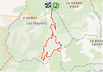

Length
20 km

Max alt
657 m

Uphill gradient
621 m
Km-Effort
29 km

Min alt
129 m

Downhill gradient
621 m
Boucle
Yes
Creation date :
2024-05-17 07:00:24.0
Updated on :
2024-05-17 13:57:05.004

FREE GPS app for hiking
 SityTrail
IGN / Geographical institutes
SityTrail Plus
The world is yours!
About
Trail of 20 km to be discovered at Provence-Alpes-Côte d'Azur, Var, Les Mayons. This trail is proposed by PhL83.
Positioning
Country:
France
Region :
Provence-Alpes-Côte d'Azur
Department/Province :
Var
Municipality :
Les Mayons
Location:
Unknown
Start:(Dec)
Start:(UTM)
287386 ; 4800037 (32T) N.
Comments