


saint ser

ego
User
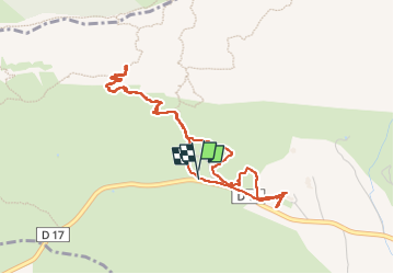

Length
5 km

Max alt
648 m

Uphill gradient
277 m
Km-Effort
8.7 km

Min alt
399 m

Downhill gradient
279 m
Boucle
Yes
Creation date :
2024-05-17 12:11:43.129
Updated on :
2024-05-17 16:32:53.518
1h58
Difficulty : Medium

FREE GPS app for hiking
 SityTrail
IGN / Geographical institutes
SityTrail Plus
The world is yours!
About
Trail Walking of 5 km to be discovered at Provence-Alpes-Côte d'Azur, Bouches-du-Rhône, Puyloubier. This trail is proposed by ego .
Positioning
Country:
France
Region :
Provence-Alpes-Côte d'Azur
Department/Province :
Bouches-du-Rhône
Municipality :
Puyloubier
Location:
Unknown
Start:(Dec)
Start:(UTM)
713604 ; 4822847 (31T) N.
Comments