


Pierlas

GeorgesV.
User
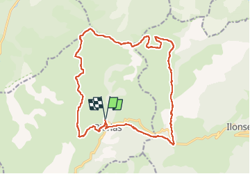

Length
22 km

Max alt
1987 m

Uphill gradient
1140 m
Km-Effort
37 km

Min alt
1072 m

Downhill gradient
1137 m
Boucle
Yes
Creation date :
2024-05-19 06:07:55.0
Updated on :
2024-05-19 14:55:58.017

FREE GPS app for hiking
 SityTrail
IGN / Geographical institutes
SityTrail Plus
The world is yours!
About
Trail of 22 km to be discovered at Provence-Alpes-Côte d'Azur, Maritime Alps, Pierlas. This trail is proposed by GeorgesV..
Positioning
Country:
France
Region :
Provence-Alpes-Côte d'Azur
Department/Province :
Maritime Alps
Municipality :
Pierlas
Location:
Unknown
Start:(Dec)
Start:(UTM)
342514 ; 4877550 (32T) N.
Comments