


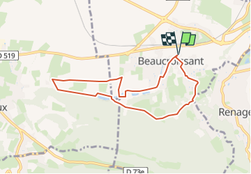
SityTrail - RS-Beaucroissant-Les étangs

raymondfn
User

Length
7.8 km

Max alt
477 m

Uphill gradient
97 m
Km-Effort
9.1 km

Min alt
412 m

Downhill gradient
97 m
Boucle
Yes
Creation date :
2024-05-19 17:21:53.739
Updated on :
2024-05-19 17:27:20.695
2h03
Difficulty : Medium

FREE GPS app for hiking
 SityTrail
IGN / Geographical institutes
SityTrail Plus
The world is yours!
About
Trail Walking of 7.8 km to be discovered at Auvergne-Rhône-Alpes, Isère, Beaucroissant. This trail is proposed by raymondfn.
Description
Rando Santé
Positioning
Country:
France
Region :
Auvergne-Rhône-Alpes
Department/Province :
Isère
Municipality :
Beaucroissant
Location:
Unknown
Start:(Dec)
Start:(UTM)
693698 ; 5023906 (31T) N.
Comments