


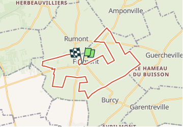
Visite de Fromont

mathis01
User

Length
19.2 km

Max alt
144 m

Uphill gradient
101 m
Km-Effort
21 km

Min alt
107 m

Downhill gradient
99 m
Boucle
Yes
Creation date :
2024-05-20 07:26:44.518
Updated on :
2024-06-16 15:43:36.443
4h39
Difficulty : Medium

FREE GPS app for hiking
 SityTrail
IGN / Geographical institutes
SityTrail Plus
The world is yours!
About
Trail On foot of 19.2 km to be discovered at Ile-de-France, Seine-et-Marne, Fromont. This trail is proposed by mathis01.
Positioning
Country:
France
Region :
Ile-de-France
Department/Province :
Seine-et-Marne
Municipality :
Fromont
Location:
Unknown
Start:(Dec)
Start:(UTM)
463145 ; 5344775 (31U) N.
Comments