


Soucieu en Jarrest_Le Marjon-Variante

trietsch
User
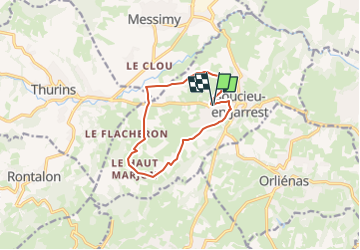

Length
10 km

Max alt
451 m

Uphill gradient
177 m
Km-Effort
12.4 km

Min alt
312 m

Downhill gradient
179 m
Boucle
Yes
Creation date :
2024-05-20 09:59:06.955
Updated on :
2024-05-20 19:13:36.304
2h48
Difficulty : Difficult

FREE GPS app for hiking
 SityTrail
IGN / Geographical institutes
SityTrail Plus
The world is yours!
About
Trail Walking of 10 km to be discovered at Auvergne-Rhône-Alpes, Rhône, Soucieu-en-Jarrest. This trail is proposed by trietsch.
Positioning
Country:
France
Region :
Auvergne-Rhône-Alpes
Department/Province :
Rhône
Municipality :
Soucieu-en-Jarrest
Location:
Unknown
Start:(Dec)
Start:(UTM)
631968 ; 5059645 (31T) N.
Comments