


20240520 MB 2 etangs

Jeanclaudebic
User
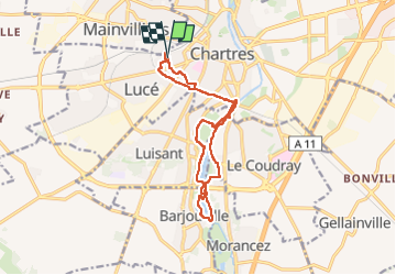

Length
13 km

Max alt
161 m

Uphill gradient
101 m
Km-Effort
14.3 km

Min alt
125 m

Downhill gradient
100 m
Boucle
Yes
Creation date :
2024-05-20 07:25:14.998
Updated on :
2024-05-20 10:01:48.618
2h36
Difficulty : Difficult

FREE GPS app for hiking
 SityTrail
IGN / Geographical institutes
SityTrail Plus
The world is yours!
About
Trail Walking of 13 km to be discovered at Centre-Loire Valley, Eure-et-Loir, Lucé. This trail is proposed by Jeanclaudebic.
Positioning
Country:
France
Region :
Centre-Loire Valley
Department/Province :
Eure-et-Loir
Municipality :
Lucé
Location:
Unknown
Start:(Dec)
Start:(UTM)
386932 ; 5366670 (31U) N.
Comments