


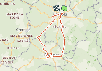
Le cheMain faisant au départ de Concots

houbart
User

Length
13.9 km

Max alt
304 m

Uphill gradient
211 m
Km-Effort
16.7 km

Min alt
238 m

Downhill gradient
211 m
Boucle
Yes
Creation date :
2024-05-20 13:26:37.832
Updated on :
2024-05-20 13:31:23.734
3h47
Difficulty : Difficult

FREE GPS app for hiking
 SityTrail
IGN / Geographical institutes
SityTrail Plus
The world is yours!
About
Trail Walking of 13.9 km to be discovered at Occitania, Lot, Concots. This trail is proposed by houbart.


Positioning
Country:
France
Region :
Occitania
Department/Province :
Lot
Municipality :
Concots
Location:
Unknown
Start:(Dec)
Start:(UTM)
392026 ; 4917364 (31T) N.
Comments