


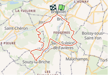
Renarde et Orge par Madagascar

olivieraron
User

Length
15.8 km

Max alt
158 m

Uphill gradient
288 m
Km-Effort
19.6 km

Min alt
56 m

Downhill gradient
289 m
Boucle
Yes
Creation date :
2024-05-20 15:08:54.202
Updated on :
2024-05-20 16:04:38.023
4h27
Difficulty : Very difficult

FREE GPS app for hiking
 SityTrail
IGN / Geographical institutes
SityTrail Plus
The world is yours!
About
Trail Walking of 15.8 km to be discovered at Ile-de-France, Essonne, Breuillet. This trail is proposed by olivieraron.
Positioning
Country:
France
Region :
Ile-de-France
Department/Province :
Essonne
Municipality :
Breuillet
Location:
Unknown
Start:(Dec)
Start:(UTM)
438889 ; 5379412 (31U) N.
Comments