


Black Licorne

apa
User
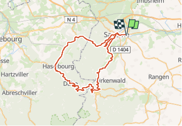

Length
68 km

Max alt
676 m

Uphill gradient
1310 m
Km-Effort
85 km

Min alt
180 m

Downhill gradient
1310 m
Boucle
Yes
Creation date :
2024-05-20 11:11:44.0
Updated on :
2024-05-20 15:59:04.632

FREE GPS app for hiking
 SityTrail
IGN / Geographical institutes
SityTrail Plus
The world is yours!
About
Trail of 68 km to be discovered at Grand Est, Bas-Rhin, Monswiller. This trail is proposed by apa.
Photos


Positioning
Country:
France
Region :
Grand Est
Department/Province :
Bas-Rhin
Municipality :
Monswiller
Location:
Unknown
Start:(Dec)
Start:(UTM)
381624 ; 5399768 (32U) N.
Comments