


20_5_24

baudon
User
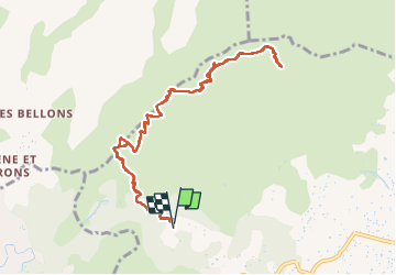

Length
11.1 km

Max alt
690 m

Uphill gradient
437 m
Km-Effort
16.9 km

Min alt
271 m

Downhill gradient
433 m
Boucle
Yes
Creation date :
2024-05-20 12:55:46.529
Updated on :
2024-05-20 17:22:24.46
4h25
Difficulty : Difficult

FREE GPS app for hiking
 SityTrail
IGN / Geographical institutes
SityTrail Plus
The world is yours!
About
Trail Walking of 11.1 km to be discovered at Provence-Alpes-Côte d'Azur, Bouches-du-Rhône, Aubagne. This trail is proposed by baudon.
Positioning
Country:
France
Region :
Provence-Alpes-Côte d'Azur
Department/Province :
Bouches-du-Rhône
Municipality :
Aubagne
Location:
Unknown
Start:(Dec)
Start:(UTM)
705710 ; 4798932 (31T) N.
Comments